


Memories of the Bureau of Meteorology
Preface
Memories of the Bureau of Meteorology 1929–1946 by Allan Cornish
Foreword
Chapter 1: My Early Days in the Bureau
Chapter 2: Some New Vistas
Chapter 3: The RAAF Measures Upper Air Temperatures
Chapter 4: The Bureau Begins to Grow
Chapter 5: My Voyage in Discovery II
Chapter 6: The Birth of the Instrument Section
Chapter 7: Darwin Days
Chapter 8: I Leave the Bureau
History of Major Meteorological Installation in Australia from 1945 to 1981 by Reg Stout
Four Years in the RAAF Meteorological Service by Keith Swan
The Bureau of Meteorology in Papua New Guinea in the 1950s by Col Glendinning
Index
Search
Help
Contact us
Chapter 5: My Voyage in Discovery II (continued)
We had a mathematician on board Discovery II who was working on statistics which had recently become available. He had a mechanical calculator on board and he was trying to estimate the number of whales on this earth. He knew the number of barbs that had been shot into whales and he knew the number that had been recovered with one mark, two marks and three. He was trying to estimate how many whales there were with no markings. From his long mathematical calculation he had some idea of how many.The Royal Navy fellows and the scientists on Discovery II were hand-picked. They were superb. Number one and I became good friends. It was his habit to appear on the bridge when the Fourth Officer was on watch. Number one doubled up on that watch because he knew the charts weren't the best. I would visit the bridge about 11pm because at that time there was always hot cocoa and Number one to yarn to. With two officers on watch we could yarn. I used to spend a lot of time with him—big, tall bloke, John McPhee. He was quite a seaman. He would always tell stories about the Royal Navy.
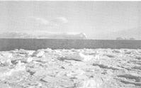
Most of the work on Discovery II was carried out by the scientific staff with the Navy people there to manage the ship, plot its position and keep things shipshape. When we came to the Balleny Islands the Navy took over and carried out the survey. This fascinated me because there were five islands in the group and very little was known about them.
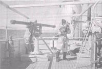
We worked about 18 hours a day using the following technique. The ship was put on a steady course. Being so close to the South Magnetic Pole the compass was unreliable. The skipper maintained a steady course by taking bearings on the sun. The electric log gave the distance travelled. The ship ran in a straight course at about seven knots. With the echo-sounder running, it was possible to plot the topography underneath the ship. The ship's artist sketched the profiles of the islands. The skipper assigned names to prominent points such as capes, mountains and headlands which the official photographer photographed. The survey team consisted of four Navy people, two operating horizontal sextants and two operating vertical sextants. Because I had operated a Barr and Stroud range-finder in the Weather Bureau I was able to operate the large Barr and Stroud range-finder on board.
People in Bright Sparcs - Cornish, Allan William
 |
Bureau of Meteorology |  |
© Online Edition Australian Science and Technology Heritage Centre and Bureau of Meteorology 2001
Published by Australian Science and Technology Heritage Centre, using the Web Academic Resource Publisher
http://www.austehc.unimelb.edu.au/fam/0524.html