


Meteorological Work in Australia
Meteorological Work in Australia: A Review
Map No. 1—February 18th, 1890
Map No.2—January 14th, 1891
Map No.3—March 12th, 1891
Map No. 4, February 5th. 1890, and Map No .5, May 27th, 1893
Map No. 6, June 22nd, 1893
Map No. 7, July 14th, 1893
Seasonal Forecasts
Droughts
Conclusion
Index
Search
Help
Contact us
Shows the ordinary summer high pressure over the south coast, having its maximum about latitude 45°, which is further south than usual, covering Tasmania, with gradual falling gradients northwards to the usual low pressure conditions of the tropics.
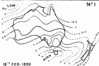
The map indicates a cyclonic centre to the north-west of Australia, where the barque Dorunda reports the barometer down to 29.47, in longitude 114°E. and latitude 15°S.
This cyclone was moving westward when encountered by the Dorunda, and probably passed through the S.E. trade belt; then recurving to the eastward, may possibly be identical with a south coast depression which appeared off the Leeuwin on the morning of the 24th, but if so it had greatly lost its energy.
The weather corresponding to this map was—Fine, except on and near the east coast from Cape Howe to the Gulf of Carpentaria, where the weather was everywhere cloudy and unsettled, with rain, heavy rains falling on the coast. Over the whole of Australia the winds were south-east, and strong. from the east through Bass's Straits.
Following, we had general and heavy continuous rains for several days in both Queensland and New South Wales, the isobar charts showing a V-shaped depression gradually extending southward into Queensland from the Gulf of Carpentaria, whilst the high pressure to the south became split up into two parts by a northerly low pressure extension towards our south coast. In Queensland and northern New South Wales many heavy floods were reported, Townsville (Queensland) having over 19in. of rain in three days.
Map No.2—January 14th, 1891
Shows a tropical "low" in the Gulf of Carpentaria, working its way southwards over Queensland, whilst to the south is a "high," having its maximum, 30.2in., over Tasmania, the south coast of Victoria, and part of New South Wales between two "lows," one approaching from the west and south of the Leeuwin, and the other to the east, covering southern New Zealand.
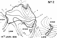
With this map we had fine weather over Tasmania, Victoria, South Australia. and Western Australia; cloudy to gloomy and very unsettled throughout Queensland and New South Wales, with rain, very heavy in former colony.
Subsequent weather—The "low" shown over the gulf country of Queensland passed slowly southwards, and on the morning of the 17th lay over the Rivirina districts of New South Wales. Very heavy and general rains continued all over the eastern colonies, and heavy floods resulted in many parts of Queensland and New South Wales, and stormy conditions affected the east coastline. The "high" shown off the south coast moved eastward, as the "low" worked its way southward from northern Queensland.
People in Bright Sparcs - Todd, Charles
 |
Bureau of Meteorology |  |
© Online Edition Australian Science and Technology Heritage Centre and Bureau of Meteorology 2001
Published by Australian Science and Technology Heritage Centre, using the Web Academic Resource Publisher
http://www.austehc.unimelb.edu.au/fam/1560.html