


Antarctic Operational Meteorology
Abstract
Introduction
The Past
The Present
The Future
Acknowledgements
References
Index
Search
Help
Contact us
In order to discover how well the various numerical analyses and prediction schemes used by the various countries represent the actual conditions observed in Antarctica a series of experiments is being conducted organised by the Scientific Committee on Antarctic Research (SCAR) Working Group on the Physics and Chemistry of the Atmosphere (PACA). This experiment known as FROST (the Antarctic First Regional Observing Study of the Troposphere) is following in the tradition of IGY and FGGE but at a regional level. Like FGGE, it has conducted Special Observing Periods and the results are currently being assessed by a group principally from the UK, US, and Australia. It is hoped that this work will lead to better numerical products and ultimately forecasts for the Antarctic region (Turner et al. 1996).
Along with the improved ability to analyse and predict the major features of the Antarctic atmosphere has come the desire to provide better services to assist Antarctic logistics, in particular the safe and efficient operation of aircraft and shipping. As in other parts of the world such advice is ideally provided by skilled meteorologists on site (in this case in the particular part of Antarctica concerned). However, such meteorologists need to have available to them the output products and guidance of the models which can only be operated by major analysis centres equipped with high computing power and global data. Thus, the best solution is to have locally experienced professional meteorologists with access to local knowledge and information (eg local high resolution satellite read out) but supported by the output from the major centres. The next-best solution is to have the services provided from a distant centre with access to all available data by a meteorologist previously experienced in the particular area. In practice, as in most human activities economics determines what level of service can be provided.
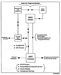
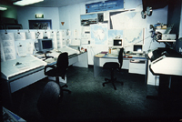
In recent years the World Meteorological Organization (WMO) noting the incidence of aircraft accidents which were weather related as well a number of shipping groundings and besettments has sought to have a series of properly equipped Antarctic Meteorological Centres (AMC) set up which would draw on the output of the major analysis centres located elsewhere in the world but utilise local knowledge and data to provide as good a service as was economically possible to expeditions and tourist operations in Antarctica. "By 1999 four such centres were operating viz those at Casey (Australia), Marambio (Argentina), McMurdo (US) and Rothera (UK) following the closure of the centre at Malodezhnaya (Russia)." The Australian AMC at Casey was established in 1991 and its present operations are shown schematically in Figure 19. The Centre is now staffed for the operational (summer) season and appropriate output provided from the Bureau of Meteorology's Regional Forecast Centre in Hobart during the winter. The Casey AMC is well equipped (Figure 20) and has direct access to all the output from the National Meteorological Centre in Melbourne via the so called McIDAS system (Man-computer Interactive Data Access System).
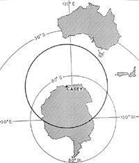
Lower—Range (heavy circle) of data reception of AVHRR satellite data at the Casey AMC.
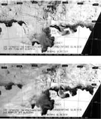
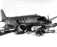
In addition to the Casey AMC it has been usual for many years for a forecaster to be assigned to ANARE field operations at the main summer operational centre or on expedition ships or sometimes at field locations. Where possible this has been continued with the main effort being centred at Davis in recent years. Such out-posted forecasters are provided with the output of the Casey AMC as well as that of several of the major analysis centres outside Antarctica. With these data and access to local information from field camps the forecaster is best equipped to provide operational advice for surface travel, aviation and shipping operations in his local area. In particular the locally read out high resolution satellite data are particularly useful (see eg. Figure 21). Among the services provided by the AMC or the out-posted forecaster are en-route forecasts for long range helicopter inter-station (eg Casey to Mawson) flights and terminal conditions, short range helicopter transfer of personnel and equipment from station or ship to local field sites and advice on ship routing for passage through the sea ice using the high resolution satellite imagery read-out and local weather analyses. In recent years with the recommencement of tourist overflights of Antarctica from Australia the Hobart office of the Bureau of Meteorology and the AMC have been involved in provision of information for this activity. As tourist interest increases in Antarctica the meteorological services for shipping, aircraft and local surface travel will become increasingly important for reasons of both safety and economics. Despite (and perhaps often because of modern technology) Antarctica remains a potentially dangerous region particularly for aircraft (see Figure 22) and ships. Improved observations and forecasts are required for better warnings to reduce the risk to life and property.
Organisations in Australian Science at Work - National Meteorological Centre (NMC)
 |
Bureau of Meteorology |  |
© Online Edition Australian Science and Technology Heritage Centre and Bureau of Meteorology 2001
Published by Australian Science and Technology Heritage Centre, using the Web Academic Resource Publisher
http://www.austehc.unimelb.edu.au/fam/1591.html