


Memories of the Bureau of Meteorology
Preface
Memories of the Bureau of Meteorology 1929–1946 by Allan Cornish
History of Major Meteorological Installation in Australia from 1945 to 1981 by Reg Stout
Four Years in the RAAF Meteorological Service by Keith Swan
The Bureau of Meteorology in Papua New Guinea in the 1950s by Col Glendinning
Foreword
Introduction
Brief History and Geography
Station Operations
Air Transport
The Port Moresby Office
Housing for Bureau Staff, Port Moresby
Staff Members and Their Families
Local Transport
Education
Entertaining, Sport and Lifestyle
Shopping Facilities
Malaria
Native Servants
Communication with Native Servants
Meteorology
Forecasting Problems in Port Moresby
Other Comments
Index
Search
Help
Contact us
Brief History and Geography
Indonesians and Malays are known to have visited the geographical area covered by the Territory of Papua and New Guinea prior to the 16th century. During the 16th to 19th centuries they were followed by a succession of European navigators—Spanish, Portuguese, English, French, Dutch and German—and England and Germany both established colonies. The history of New Guinea prior to 1945 is, however, a task for the historian and I will go no further here.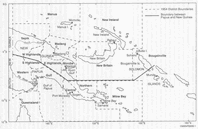
The history of the Territory, post-1945, can be epitomised. Under an agreement with the United Nations Organisation in 1946, Australia became Administrator of the Territory of New Guinea. In 1949, the Australian Government passed a Bill that combined New Guinea and Papua, thus creating the Territory of Papua and New Guinea.
The Territory of Papua and New Guinea, and the 15 Administration Districts into which it was sub-divided, circa 1954, are shown on the accompanying map. In summary, the Territory covered the geographical area between the equator and latitude 12°S, extending eastward from its border with then Dutch New Guinea (primarily longitude 141°E) to around longitude 156°E. Its main landmass comprised the eastern half of the large island of New Guinea. It also included the major islands of New Britain and New Ireland, and many smaller islands and atolls to as far east as Buka Island and larger Bougainville Island in the Solomon Islands chain.
With the major exceptions of the delta country at the head of the Gulf of Papua and swamp areas of the Sepik River (and of similar smaller areas on other rivers), New Guinea, and the other larger islands of the Territory are primarily mountainous. Two peaks on the mainland ascend to 14 300 and 15 400 feet. Some of the smaller islands and, of course, atolls are, however, comparatively flat. The terrain contributes significantly to the Territory's generally high rainfalls and mainly swiftly flowing rivers; but Port Moresby, an exception, is in a relatively dry area.
People in Bright Sparcs - Glendinning, Colin (Col)
 |
Bureau of Meteorology |  |
© Online Edition Australian Science and Technology Heritage Centre and Bureau of Meteorology 2001
Published by Australian Science and Technology Heritage Centre, using the Web Academic Resource Publisher
http://www.austehc.unimelb.edu.au/fam/0582.html