


Seventy-Five Years at Willis Island
Preface
Foreword
Chapter 1: Willis Island Today
Chapter 2: Willis Island is Conceived
Chapter 3: Willis Island is Born
Chapter 4: The Early Years
Chapter 5: Life in the 1930s
Chapter 6: Willis Island at War (1941–42)
Chapter 7: After the War
Chapter 8: Willis Island—1960s Style
Chapter 9: The Value of Willis Island
Chapter 10: The Original Inhabitants
Appendix 1: Willis Island Milestones
Appendix 2: Willis Island Officers
Appendix 3: Log of Willis Island Observations, December 1922
Appendix 4: References
Index
Search
Help
Contact us
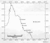
The Bureau of Meteorology Station, WMO Number 94299, known as Willis Island is situated at 16° 17' 45" South 149° 58' 30" East. It is on the southernmost of a group of three islands, which with their associated sandy cays stretch in a NNE to SSW line for about 12 kilometres. Willis Island itself lies roughly NW to SE and is about 500 metres long and 150 metres wide, and rises to just under 10 metres above sea level. It is in the Coral Sea some 245 nautical miles northeast of Townsville and a similar distance east of Cairns.
The current staffing at the station is normally four, being three Technical Officers (Observer), one of whom is Officer-in-Charge, and one Technical Officer (Electronic Engineering).
The three observing staff maintain an almost 24 hour observations coverage. A Micromac Automatic Weather Station (AWS) sends out hourly observations of wind speed and direction, temperature, dewpoint, pressure and rainfall. Every three hours the observers add cloud, visibility and weather details to make up a full synoptic report.
Rainfall is measured by a standard rain gauge, a Dines tilting syphon pluviograph and tipping bucket rain gauge linked to the AWS. Wind observations use a Dines pressure tube anemograph, which provides a record of winds up to 200 knots (370 km/h).
Upper air radar wind flights are performed four times each day using a hydrogen filled balloon and an attached radar target of foil covered foam. These are followed to heights of over 20 000 metres using a WF100 radar and a computer based console (PC RADWIN). At 9am, the normal 100 g balloon is replaced by a 350 g balloon and a radiosonde is attached to the train. Besides the winds, this flight provides details of pressure, temperature and humidity through the atmosphere. As the balloon ascends the data is transmitted to a separate ground based computer (PC CORA) which receives and stores the data.
 |
Bureau of Meteorology |  |
© Online Edition Australian Science and Technology Heritage Centre and Bureau of Meteorology 2001
Published by Australian Science and Technology Heritage Centre, using the Web Academic Resource Publisher
http://www.austehc.unimelb.edu.au/fam/0601.html